Four War Tour
In 2018 I travelled to Belgium and Northern France to explore the countryside and to visit the battlefields of Agincourt, Waterloo, The Somme, Ypres, and Dunkirk. The trip lasted five days but the impact of seeing so much of the landscape of war and its devastating effects would last a lifetime.
Individual Posts:
You can read about the whole trip in one go on this page, or if you’d prefer you can read the individual posts from each of the days of the trip using these links:
- Four War Tour Day One – 7 August 2018
- Four War Tour Day Two – 8 August 2018
- Four War Tour Day Three – 9 August 2018
- Four War Tour Day Four – 10 August 2018
- Four War Tour Day Five – 11 August 2018
The Whole Trip:
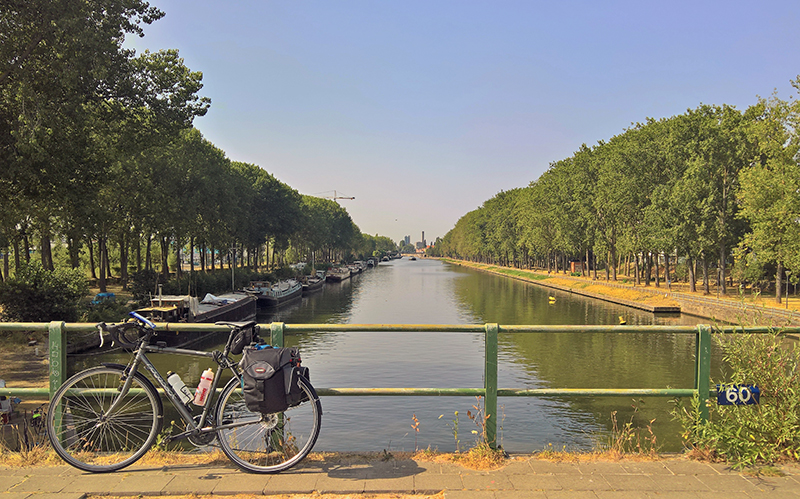
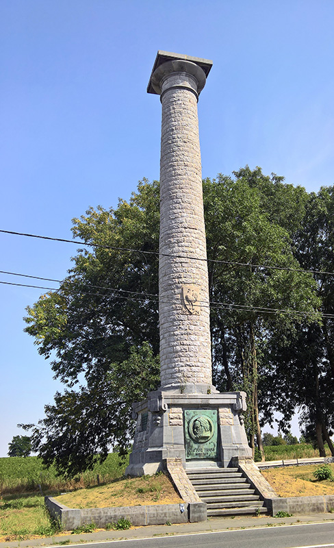
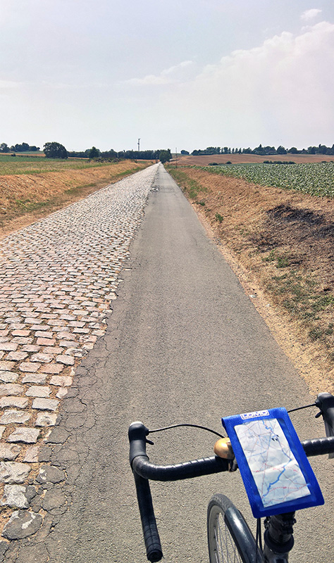
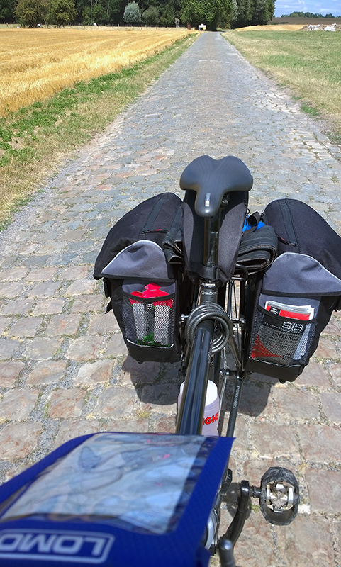
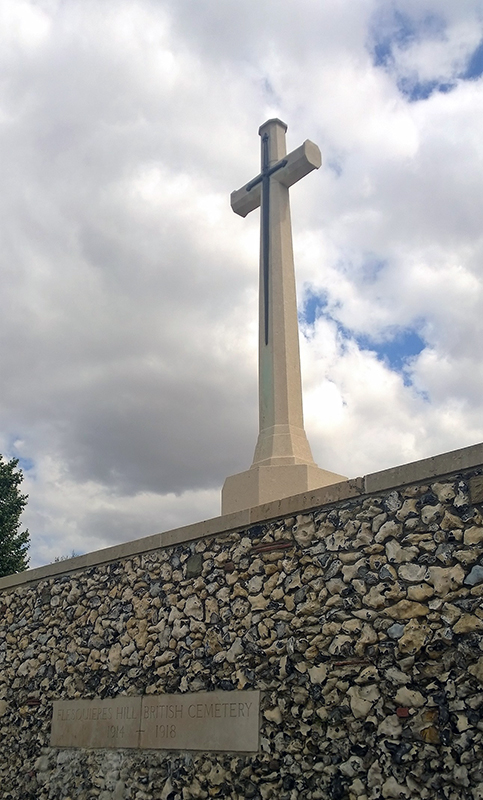
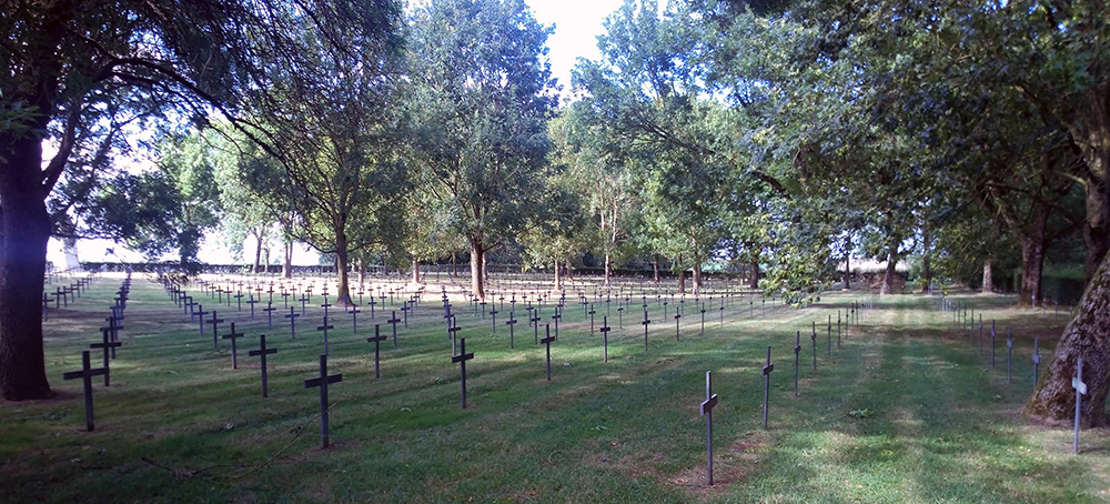
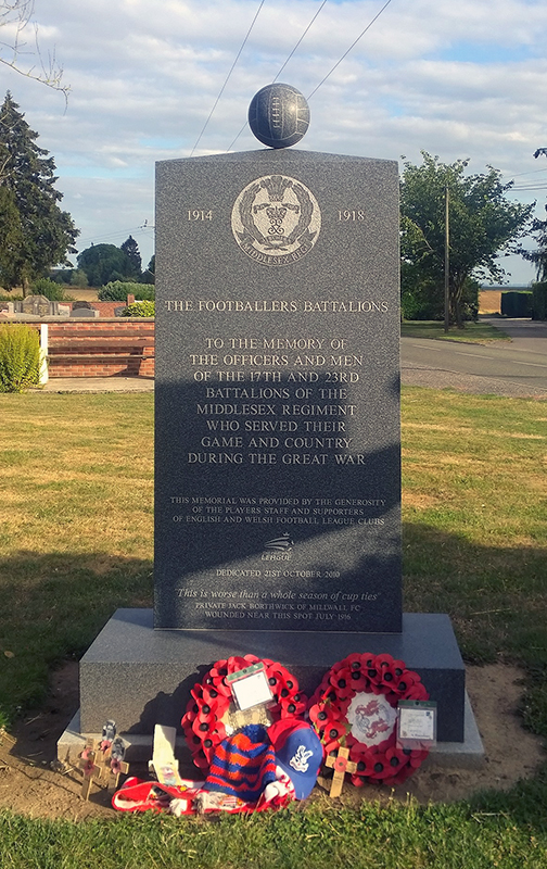
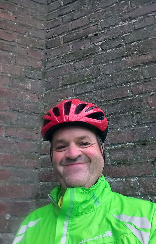
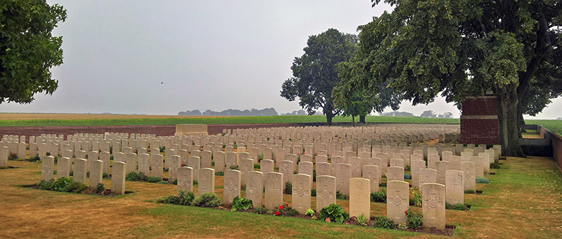
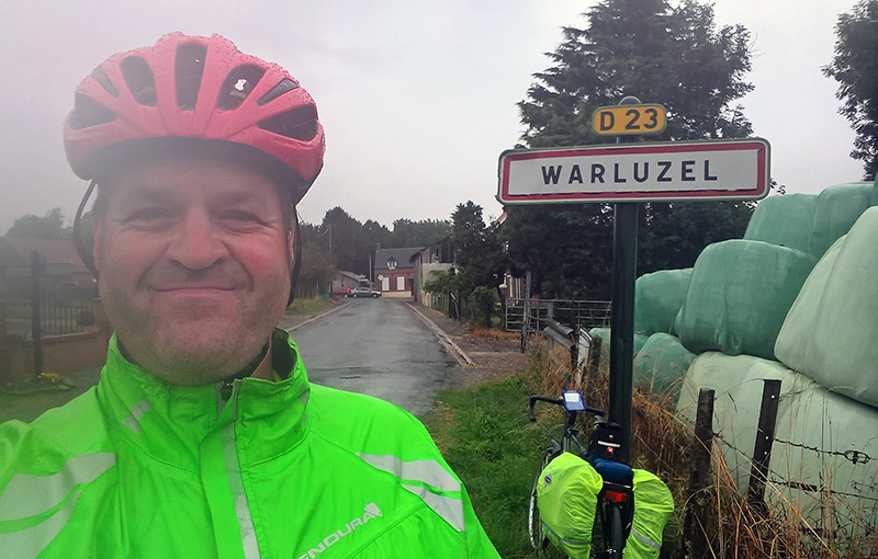
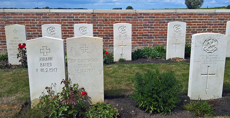
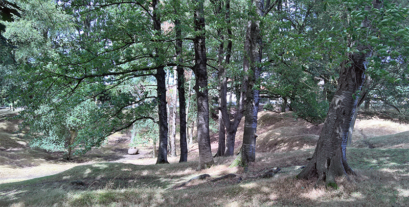
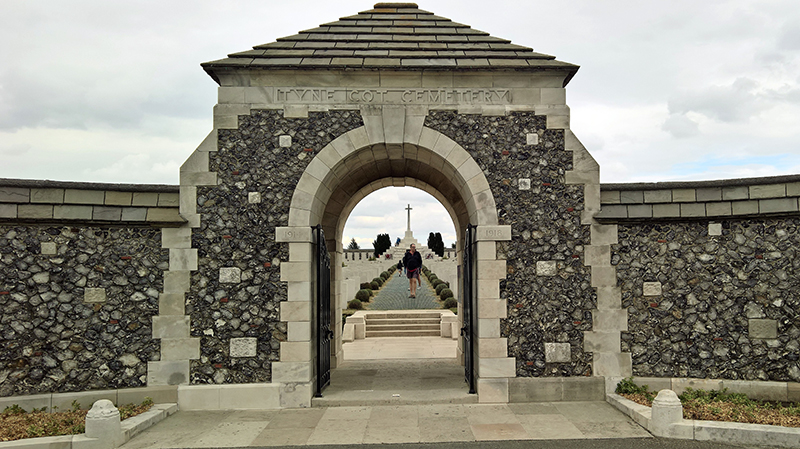
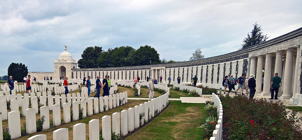
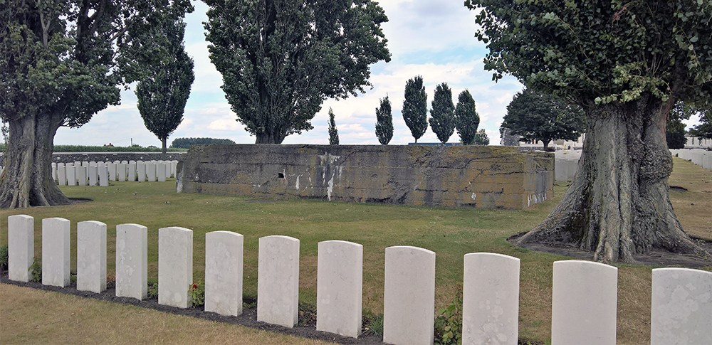
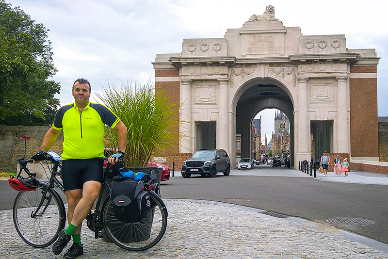
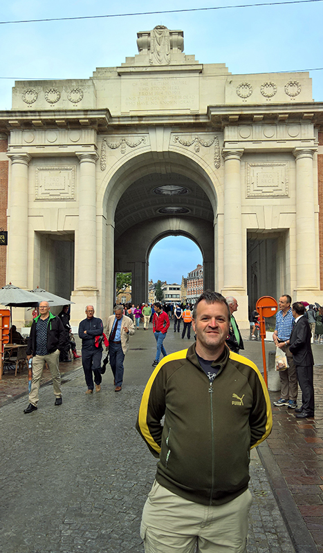
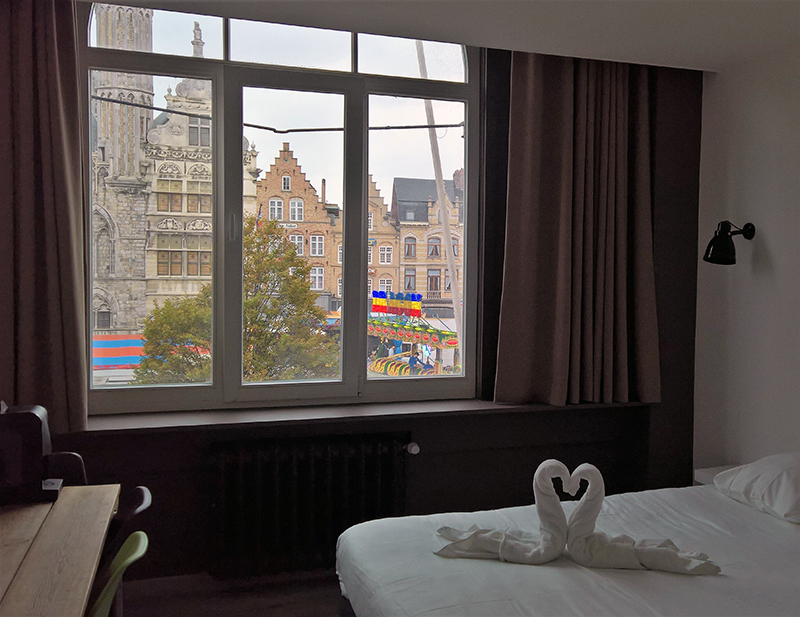
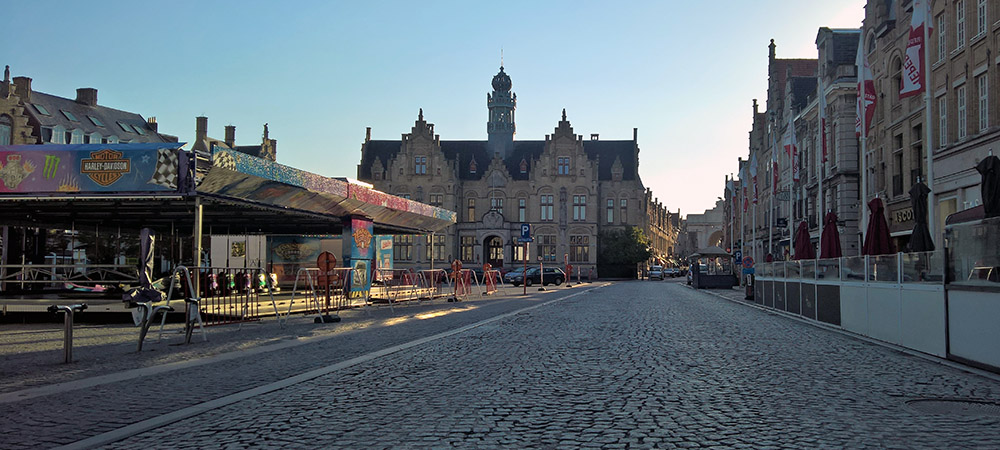
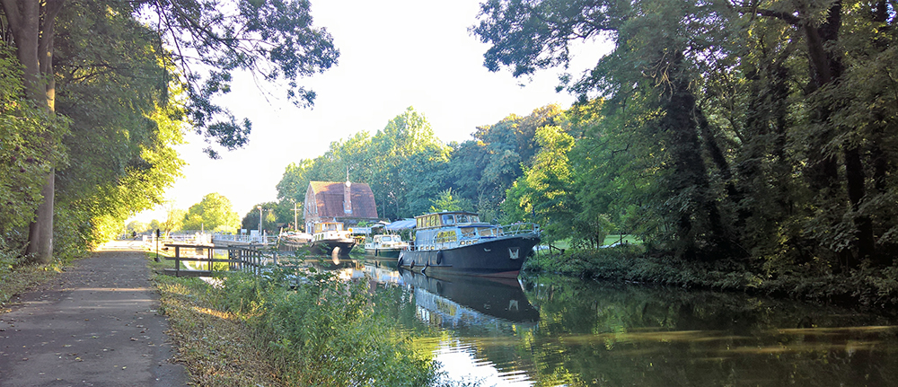
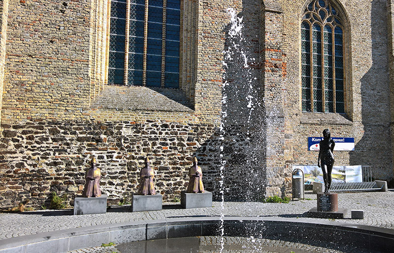
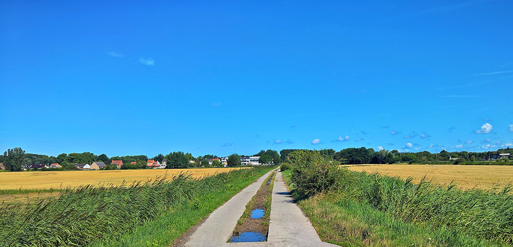
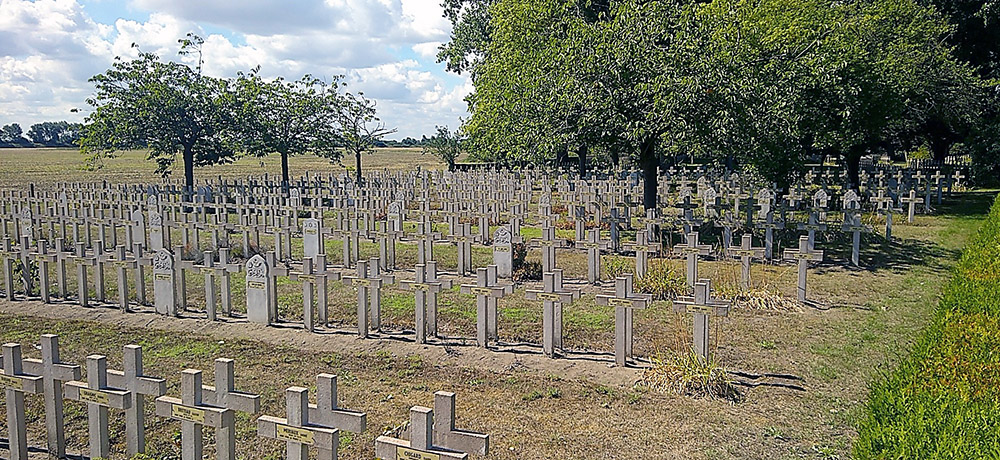
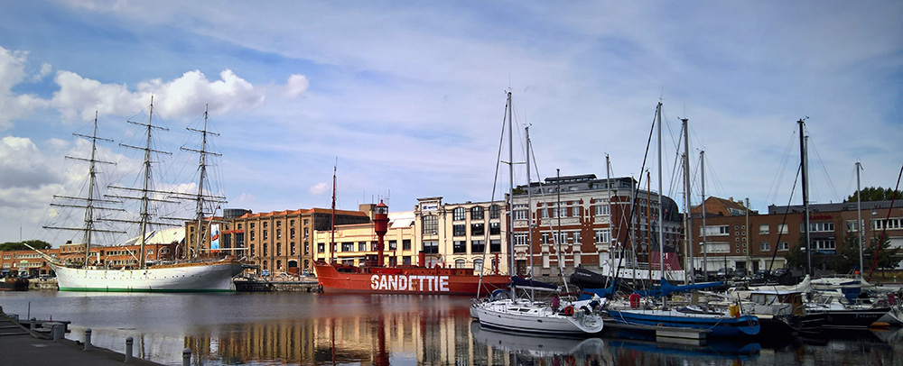
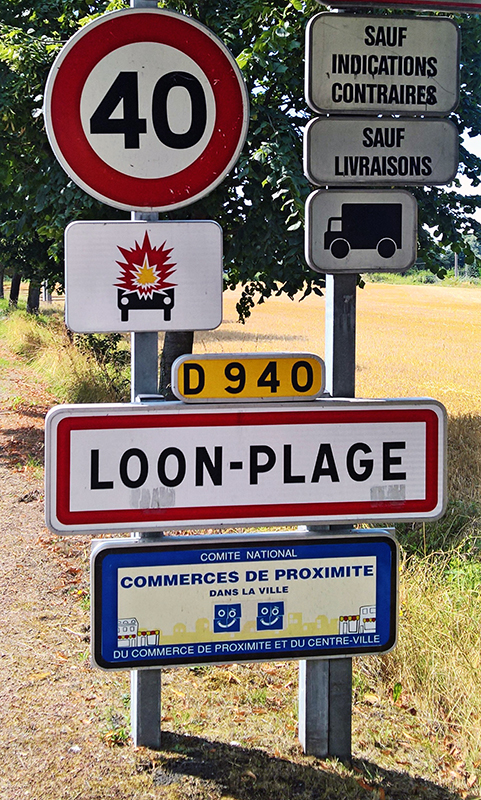
The rain overnight in Thulin was something special. When I went to bed my room was hot so I had opened the window. I was woken just after 1am by the combined noises of the window rattling and the rain soaking the curtain and falling onto the inside of my window sill. Those noises however paled when compared to the incredible noise and light show of the massive storm that was raging directly overhead. I watched the display out of the bedroom window for a bit before (mostly) closing the window and trying to get back to sleep. I think the storm carried on for a while as when I awoke again in the morning I knew I had had a restless night. It wasn’t just the tired legs feeling that a solid day’s riding can leave give. The room had heated up again after my closing the window and so, feeling hot and stuffy I had a shower and then wrote up my diary for the previous day’s ride (I carry a small notebook with me to record my trips and serve as an aide memoir for writing this blog). Breakfast was a simple self service continental buffet. An English speaking guest, an elder gentleman who I suspect might be part of the furniture at the hotel, showed me the ropes. A group of workmen alternated between eating bread and cheese on the table opposite and venturing outside for one of a large number of cigarettes they worked their way through over breakfast. The overnight rain had stopped but the morning was grey and overcast and the temperature was nothing like that of the previous day. After breakfast I finished my preparations, took my bike from the outbuilding that it had spent the night in, and made ready for the off. After a matter of only metres I passed the village store so deviated in to get supplies: some bread rolls and bottles of pop: I still had some crisps, cheese and salami from the shop in Eisengen that I stopped at yesterday. The first few miles were easy enough going although I was pushing into a small headwind. Just outside of Thulin I passed a field, marked with a number of wind turbines, which my host at the hotel had told me was the site for a part of the Battle of Mons; one of the first battle fields of the First World War. Here in 1914 the British Expeditionary Force had a very early encounter with the German Army. Losses here led to the B.E.F. retreating back to the coast. A few small villages followed and somewhere around here I passed the border into France. Crespin was the name of the first French village I entered. I had thought that the border might have been the pretty bridge I stopped at on its edge but my maps now tell me I had crossed over about a half a mile beforehand. My stop at the bridge took longer than planned. A quick and pretty photo opportunity became a major frustration as my main phone/camera refused to work. Fortunately I was aware that it was starting to reach the end of its life and had brought an older phone with me to serve as my GPS recorder for the trip. That phone was now going to double up as the camera for the rest of the day. It was whilst cursing my faulty handset that I looked into the village and noticed that the signs were slightly different. That was my first indication that I was indeed now in France. I then realised that all of the car number plates were also now French registered. It’s quite impressive that despite the easy and fluid nature of international travel here that everyone seemed to have the correct license plates. The first miles in France were fairly uneventful taking me through Vicq and Onnaing and then following the main road towards Valenciennes. The outskirts of the town (twinned with Chatham!) are fairly plain. Rather than trying to navigate around some side streets I stayed on the main road until I came to the inner ring road. The first section proved easy riding as roadworks had closed the carriageway to everyone bar cyclists. Further around the ring road I rejoined the traffic and passed a section of the old town wall. I then had to navigate around a tricky, busy, roundabout, but was soon heading back out of the town again having avoided the town centre. I made my way onto a canal tow path at just the right time to choose to stop for a quick bite to eat. I was only to follow the L’Escaut Canalise for a short distance; although it was long enough to find my way blocked by a tree which had, presumably, fallen in the overnight storms. With no easy alternative route I had to push my way through the foliage in order to carry on to the edge of Thiant where I left the towpath and rejoined the local roads. Upon leaving Thiant I came upon my first proper, and quite unexpected, stretch of Pavé. Unlike the short section outside Waterloo yesterday there was no avoiding these cobbles. I braced myself for the shaking and rattling but did actually find it to be quite good fun. The cobbles lasted the remaining miles into the next village though and by the time I dropped down the bumpy slope into Haspres I was glad to see the end of them. I mentally revised my plans for the day. After watching the Tour de France route come near this way during Stage 9 just a few weeks earlier I had planned the next part of my route to take in the first two sections of Pavé that the Tour had taken on its route between Arras and Roubaix on that day. It was easy to add the first section in with only a minor detour, however adding the second section had involved including an additional 5 mile detour.. Having now already completed one good section on the cobbles I therefore made the decision to abandon that detour and include only the first section. With that in mind I headed stragith on through Avesnes le Sec towards Iwuy. My water bottles were starting to get low now. I rode up and down the main street in Iwuy but there was no shop. Instead I stopped at the village church and had some refreshments. I was going to be riding into Cambrai within a few miles so I was sure that I would find something there. t turned I did not even have to go that far. As soon as I turned the other direction out of Iwuy I came upon a small supermarket and was able to stock up there. A very short distance later I hung a right to head into the pretty village of Thun. This was the short diversion required to take me to the section of pavé that I was keeping on my route. I hit the cobbles on the outskirts of the village as they made their way up a slow rise. The Tour riders had come the other direction but I was glad to be slowed by the hill; hitting these at speed must be something else – but the Tour de France riders aren’t carrying panniers and they have easy access to mechanics if required. There had clearly been a large number of Bob Jungles fans here as his name was painted a number of times on the cobbles (his was the only name that I saw). I carried on jolting and bouncing; mostly enjoying the experience but glad that I was only doing a couple of short sections of cobbled riding. At the end where the cobbles stop someone had painted the words “Are You Ready” on the road. For the Tour de France riders on 15th July this was just the start of 15 sections and over 22km of cobbled roads awaiting them. For me the question was too late. That was my Pavé adventure complete. I rode the short distance into the centre of Cambrai. Cambrai now doesn’t stick in the memory. Passing by I stopped to look at, and have a break at, the main town church but I was soon back on the way and, as seemed to be becoming habit on this ride, left the town by joining a waterside path; this time the towpath of the Canal du Saint Quentin. There was only a handful of miles alongside the canal before I reached the bridge which marked my turning off point. Leaving the canal I started a nice gentle climb back up onto open countryside. I crossed over a motorway, and rose up onto an open plateau marked with wind turbines and the occasional roadside chapel/shrine. The wind was still in my face as it had been all day and I felt its effects more on this exposed land. Then, suddenly, right in front of me (well just off to the left in reality) I saw the first of the many, many war cemeteries that I was to encounter along the remainder of the day’s riding. Whilst I was aware that a very large number of graves were spread across a great number of cemeteries I had not realised just how many cemeteries I might be passing and over how large a stretch of the land they covered. In planning my ride I had picked a handful of key sites around the Somme and Ypres to visit. How foolish I was to think that those pre-planned sites would be the main part of the remembrance element to my trip. The cemetery of Flesquieres Hill itself is relatively small; a mere 589 men are buried here! I would come across many larger in the days ahead so in some ways this turned out to be good preparation. The cemetery is raised up above the ground a little and only upon climbing the steps up did the beauty of the site become apparent. The work of the Commonwealth War Graves Commission, and the various French and Belgian bodies with whom they work to maintain these sites, is truly inspiring. Just to the side of the cemetery and built down and into the land on which the cemetery sits, is the new museum, named “Cambrai Tank”. “Deborah” a Mark IV tank, was involved in the fighting here in 1917. Fatally damaged (her crew are all buried in the cemetery) her remains where left buried after the war until 1998 when they were excavated, leading to the building of this amazing museum dedicated to her and the story of the new mechanised beasts of the Battle of Cambrai. I wasn’t originally sure about going in as I knew that I had a lot of riding still to do but I am so glad that I did and cannot recommend the museum highly enough. The building itself is amazing; replicating the concrete bunkers Deborah was attacking and is quite stunningly laid out with a mix of brilliant interactive displays setting the scene, and then the beautifully arranged remains of Deborah herself. Leaving the museum and bowing my head again to the cemetery I continued heading West across the open countryside. In Havrincourt, from its gates I looked down to the Chateau de Havrincourt. At first glance the Chateau is typical of many such French buildings, however this one dates only from 1925 when the new building was made to replace the one destroyed by the Germans in 1917 when the Hindenburg line was built straight through the village and the original structure. Slightly further west again I crossed high over the Canal du Nord which was itself the subject of heavy fighting. The next site for me to stop at was another cemetery; the small but lovely site of the Beaumetz Cross Roads Cemetery. I was beginning to realise now that there might be more cemeteries around the area than I had anticipated. A couple of villages later I stopped in Villers au Flos. I had only stopped here opposite the church as it was one of the places at which I needed to swap over the pages of mapping in my handlebar map holder. As I was about to set back off I noticed a sign pointing towards a German War Cemetery. I wasn’t sure how far away it might be but looking at the road it was signed down I guessed (correctly) that it wouldn’t involve a long detour so I went to explore. The smaller cememteries at Flesquieres and Beaumetz had not prepared me for this; my first large scale war cemetery. The German cemetery was as beautifully and peacefully laid out as the CWGC ones. Indeed with many more trees planted around the site, the layout felt even more relaxed and very friendly. Instead of the stone headstones used in the allied cemeteries, the Germans are buried under iron crosses. The effect is to increase the space between the graves which allows you to see more at any one time. There were many, many crosses here and it took my breath away. I thoroughly despise the jingoistic, nationalistic crap that has enveloped and soured the U.K. since the referendum to leave the E.U. It is the biggest mistake of our generation and here lay the reasons (several thousand of them) why. These men here were as much our brothers as those under the clean white stones of the Commonwealth graves. This whole trip was to be a constant reminder of how we must never allow Europe to be so divided again; and yet here we are in the U.K. architects of the opposite. Just as this deep sorrow was coming upon me I wandered further into the cemetery and then noticed something that had initially escaped my attention. Beyond the first line of crosses I had encountered next to the main path, all of the other crosses bore not one but two names. There were twice as many dead here as at first appeared. 2449 men are buried here. I did allow myself to cry a little. Not for the last time today. Having regained my composure I headed back out of the small gate from the cemetery, mounted the bike and headed off on my way. Outside of the next village, Le Transloy, I came across my first French cemetery. This was mostly the main village cemetery but at its front was a large open area which was apparently the mass grave for several hundred men killed in the war; their names carved on a large stone behind. I only had to pass through one more village to come across the next major cemetery; the CWGC Guards Cemetery at Lesboeufs. This is the final resting place of 3,137 casualties, of which 1,644 remain unidentified. Most of the photos I took here appear to be out of focus; I’ve included the best remaining ones here. I can only assume that I must have been crying again. At the top of the hill a short ride from the cemetery is the monument to mark where the main fighting that led to the full cemetery I had just left took place. The cross now sits on the edge of a picturesque field; 100 years ago this landscape would have been anything but lovely. From here it was a short ride to Delville Wood. Delville Wood was the first of the sites that I had actually put as a point on my route plan. The wood was the site of one of the bloodiest engagements of the Somme in 1916. It was almost completely destroyed in the fighting but the trees have since been regrown. Only one tree remains from the original wood. My detours had meant that I had turned up too late to visit the Museum in whose grounds the tree sat but there was more enough memories to take in here. The main feature of the battle site now is the massive monument to all of the fallen of South Africa across the whole of the Great War. The monument is a massive structure that reveals more and more of itself as you get closer. The original monument did not contain any names but an addition was made to mark the centenary of the battle on which the names of all the South African fallen are recorded. It’s a big list. The photo below shows only a fraction. I didn’t stray far into the wood as I had left my bike unlocked at the gate; and whilst I didn’t really expect anything to happen to it I didn’t wish to tempt fate. I walked just far enough to ascertain that the marker stones I could see were recording the names of the ‘streets’ that had been made in commemoration of the trench lines: Regent Street, Rotten Row, Princes Street, etc. Across the road from the monument and on a direct line with it is the battle field cemetery (for those whose bodies were recovered; for a great many more men the wood remains their final resting place – if resting is the right word). The cemetery, containing the bodies of over 5,500 men, was yet another vast and stark reminder of the huge loss of life here (remembering that only one half of the fighting is represented in this plot). The sun was starting to lower now and the low light made the strange beauty of the cemetery even more powerful. I sat here a while and would have happily stayed longer but I still had a few more miles to ride into Albert so I pulled myself up from the bench I was sitting on, walked along just a few more of the very many lines of the dead, and headed back onto the bike. At the junction just beyond the cemetery I came across the recently installed memorial to the ‘Footballers Battalions’ – the 17th and 23rd Middlesex – who included in their ranks a number of professional London based footballers (and indeed from other clubs). The monument was added in 2010 by the Football League. The sign to another monument led to me adding an extra mile or two of detour; the monument to the fallen of New Zealand on the top of another hill just to the North of Longueval and Delville Wood. I headed back in the direction of Albert but again did not go far before coming to another of the massive cemeteries; this time Caterpillar Valley. Another 5,573 men are buried here; 3,798 of whom are unidentified. The names of 1,200 fallen of New Zealand are also recorded here. As at Delville Wood the low, late summer sunlight added to the power of the setting and situation and I sat down and had another little weep. Another few smaller cemeteries were sited a short way off the road; Thistle Dump. Flatiron Copse. Gordon Dump. I didn’t stop at any of these. I didn’t have the physical or emotional energy left to make the detours. A long day riding into the wind and all the tears were taking their effect now. I did however make one final turning for the short trip to the final site of the day; the massive hole in the ground known as Lochnagar Crater. The result of tunnelling and exploding underneath German trenches, a hole 330 feet across and 70 feet deep remains as a permanent memorial. The explosion occurred on the first day of the Battle of the Somme; 2 minutes before the main fighting started. Unknown numbers of Germans were killed both in the explosion itself. Thousands more died in the fighting that then occurred in the immediate aftermath. As the British tried to take the ground their advance was scuppered by the massive crater. The new obstacle largely served to leave them brutally exposed to the German guns. By now I was physically and emotionally exhausted. Fortunately my bed for the night was not far away. Albert was the main town at the heart of the Somme region and the Ibis hotel that I was aiming for was on this side of the town. I quietly and reflectively rode the final mile or two and silently glided into the hotel car park. I checked in, showered, and returned to the bar and restaurant for a rather rubbery steak (but some nice fries) and a beer. Unsurprisingly perhaps the bar was full of a couple of coach loads of other Brits on tours around the battle sites. However I was too in my own thoughts from the day to engage with them and so quietly slipped back upstairs to my room and to my nice comfortable bed. Stats: I woke up at half past six and gathered up most of my belongings ready for the off, then went downstairs for an Ibis continental breakfast. It was much as expected; nothing out of the ordinary but it certainly set me up well for the day ahead. I took my time using the opportunity to write up my diary for the previous day’s ride. I had been too drained to write it the previous evening. I was fully packed and ready to go by quarter past eight after a chat with the coach tourists from Merthyr Tydfil. I was in a much more open frame of mind and enjoyed discussing our relative methods of touring the battlefields. They were heading for home this morning and though they had enjoyed their trip they looked like they were ready to leave the coach travel behind them. From the hotel I started heading in towards Albert town centre although I never did ride into the town proper. Just across the first roundabout was a Lidl supermarket. It wasn’t quite yet open but there was a small queue forming so I gathered that it wouldn’t be long before it was. Although not ideal for small scale provisions I needed some supplies. I was in and out quickly once the doors opened at eight thirty. Loaded up with saucisson, crisps (I had to buy a six pack), cheese, bread and chocolate I was now fully prepared for the day ahead. The day was cloudy but at present the weather seemed to be set fair enough. I was braced for a shower or two but this should be a good day. I skirted down some side streets and then around towards the River Ancre and the ‘Velodrome’ park (there was no sign of a race track or I might have taken a quick spin). I followed the valley upstream, winding around either side of the river, slowly and gradually climbing away from Albert. I passed the sign for the evocatively named ‘Blightly Valley’ cemetery at the end of a footpath. I didn’t stop to visit but nodded as I passed. It looked like a lovely peaceful last resting place. A short way further and the road started to climb out of the valley and ahead of me I could see my first destination of the day calling to me from the top of the hill. Although still some distance away the monument to the missing of The Somme on the hill at Thiepval makes a big first impression. I pulled into Thiepval car park just before nine thirty. After locking my bike up I loitered by the (locked) Museum doors. The nice lady inside took the subtle hint, opened up slightly early, and obligingly offered to look after my panniers whilst I looked around. Visiting the monument is free however there is small charge to enter the Museum. It is definitely worth paying as the Museum is an incredibly well designed space with displays on trench life and artefacts discovered in the area, all surrounded by an amazing drawing representing the fighting on 1st July 1916. The day was to become the deadliest day in the history of the British Army; within 12 hours over 19,000 men were killed and many more wounded. One wall in the Museum was very simply composed of photographs of a small proportion of the faces of the missing men from the Battle of the Somme. After spending about half an hour or so in the Museum I left to head outside and get some air and to head to the monument itself. Bearing the names of 72,337 allied soldiers who died with no known grave the Thiepval Memorial is quite some sight to behold and difficult to take in. Every wall is crammed full of names the whole way up. Just behind the memorial a small joint French and British cemetery contains the same number of graves of men of each nation to show how they died side by side. Its an incredibly beautiful location and an inspiring monument (designed by Edward Lutyens). One of the small showers I was expecting started as I was at the site but it didn’t look like much and it wasn’t enough to put me off hanging around a little while longer. Eventually I headed back to the museum desk and collected my bags. It was still raining a bit outside so I put on my wet weather gear just in case before heading back to the bike and getting on my way. Close by the memorial I passed the smaller Connaught and Mill Road cemeteries, and also the Ulster Tower which commemorates the men of that province who fell here throughout the Battle of the Somme. The rain was still falling; although it was stop start the road was now wet enough that I took care as I descended back down from the ridge into the Ancre Valley and the small hamlet of Hamel before climbing back up onto the next ridge. I was just coming up to the entrance to the Beaumont-Hamel memorial and preserved battle field when suddenly a huge bolt of lightning flashed in front of me. The roar of the thunder was impressive and immediate. The downpour started at the same moment. I was suddenly directly underneath a storm cloud. The heavens properly opened. I sped my way towards the site entrance. A nice Canadian lady (this was the site where the men of Newfoundland fought and died) cheerily told me that I couldn’t bring my bike into the site. I understood that but asked if, due to the sudden downpour, I might be able to put my bike in her hut? No that would most certainly not be allowed. I must use the bike rack in the exposed and open car park opposite. Might I then ask if she would look after my panniers to prevent them getting soaked? No. Sadly this was out of her control. French rules about terrorism, you see. Awfully sorry. No one had apparently told any of the French hosts at the various other sites I stopped at about this rule but she was quite insistent. Reluctantly I locked my bike up on the railings and trusted that a) nobody would be stupid enough to be out in this rain to steal my bags, and b) the flimsy water proof outer cover and the various carrier bags inside the panniers would provide enough protection for my clothes and equipment. The rain and the officiousness did sadly taint my visit. I believe that the site in its entirety is quite large with lots to see. I explored only a small section but it did give me the best understanding so far of the layout of the trenches. Although left to slowly return to nature the trench lines now appear like the banks and ditches of prehistoric archaeological sites, albeit in a much more haphazard seeming layout (the front line trenches were dug in zig zagged formations to prevent a direct hit from a heavy gun damaging too big a section of trench). I headed to the Caribou memorial which forms the centrepiece of the site and took a quick look around the remains of the trenches close by. The rain, if anything, got heavier and there was no shelter. I took in the site as best as I could and as quickly as I could. The photos here are not the best pictures I have ever taken. I was trying to prevent my camera phone getting wet although the lens was inevitably damp. This causes some of the blurred effect on the photos; however mostly that is just the rain obscuring the views. I gave up on plans to explore any further and headed back to the bike. At least if I was going to get soaked I might as well get on the move. Passing the entrance hut the Canadian guard lady had vanished inside and showed no signs of coming out to say goodbye to me. At least with the bags still on the bike (I was correct and nobody had stolen anything) it only took a second or two to get unlocked and moving; heading in a rough North Westerly bearing. The rain continued although it was good to be moving now. I think the rain might have slightly eased off. However before long there was more thunder and lightning and the rain was back in full flow. Ahead of me I saw the church at Auchonvillers. I could not avoid the rain for long (I still had a whole day’s ride in front of me and a B&B to get to) but there was no point in staying out in this; and surely I wouldn’t need to shelter for too long. I climbed out of the saddle and spun as quickly as possible in order to sprint the last distance to the church. I jumped off the bike, picked it up, and almost ran headlong into the locked church door. There was to be no sanctuary for me here. I found the only vaguely sheltered corner of the outside of the church and pressed my back tightly against the fabric of the building to keep as much of me away from the worst of the rain as possible. I’m not sure how long I stayed there; probably no more than ten minutes; but eventually the weather cleared a little. By which I mean it was now only raining heavily. I might as well carry on. I sploshed my sodden shoes (the overshoes had kept my actual shoes dry for maybe two minutes before they were themselves soaked through) back to the bike and climbed back on. The rain water was pouring in rivers along the road and I gingerly headed off. I saw the Sucrerie cemetery across a field but didn’t turn off to visit. Nor I did I do more than stop at the outside of the Euston Road cemetery that I passed right by. The rain was persistent but now more varied in its intensity. At some short occasions it was almost light, but for most of the next few miles it was fair to heavy. I rode through Colincamps. It was probably pretty but I didn’t really look. The next village was Sailly-au-Bois. I think this is also quite pretty. It did at least have the distinction of having an open porch to its (locked) church so I pulled in to check the state of my bags (wet but not awful; the waterproofing was trying its hardest to do its job although my paper work was starting to feel the effects) and to slightly reduce the weight of my load by starting on my Lidl picnic. Bayencourt was little more than 3 or 4 houses and farm buildings at a cross roads. On the approach into Souastre the heavens opened again. Spotting an open fronted farm outbuilding I pulled over and leant my bike against a tractor whilst waiting for the latest burst to pass over. A boy and a cat came out from a neighbouring barn to see who or what I was. I nodded a bonjour but I don’t have conversational French for 7 year olds. I think the cat might have understood a little of my English, but he wasn’t letting on in front of the boy. We stood together awkwardly. They got bored before the rain stopped and headed back to their other barn. Here are a couple of pictures from the shed. They are terrible but I think the blur and haze gives something of an impression of the conditions. One of them also shows the cat. Saint Amand was the next village. Like the previous settlements I’m sure its pretty but I rode on through it without really taking it in. However before I actually reached it I did come across the mausoleum of the Family Masclef which suddenly appeared around a corner just before the village, slowly being swallowed by the hedge behind it. In the rain and the gloom it was quite a sight, and not a cheery one. Guadiempré and Couturelle came next. I know this as I’m looking back now at the record of my route on Strava. I’ve ‘revisited’ them using Google Street View but I do not recall them at all. All along this area the landscape was open and slightly rolling and undulating. Just the type of countryside I love and that France does so well. I recall being happy out in the open, even in the rain which was still varying in volume but had largely settled on ‘persistent’. I just don’t recall any specifics of the villages that I passed through. I don’t have any photos so nothing apparently jumped out at me enough to stop and photograph it (and I normally don’t need much excuse to stop to snap a picture). The next photo that I do have is this one. It’s me just entering the village of Warluzel. I was by now at the stage of tour where I’ve probably been in my own company for too long. I amused myself that this must be the French equivalent of Somerset and that I might soon come across a bunch of old yokels singing “J’ai une nouvelle moissonneuse batteuse”. Sadly that didn’t happen. I just found that I was starting to get hungry, that it was about lunchtime, and that there was a bus shelter that I could keep dry in and rectify the first situation. I felt refreshed for a decent rest and some food. The rain was still falling but it had settled into a steady rhythm and was much less intense than during the morning. The miles (kilometres) continued to tick over and the villages continued to pass by with little to differentiate them. I was still enjoying the open countryside and the small hamlets that appeared on a regular basis but they didn’t have much excitement to offer. I stopped in Beaudricourt to snap this colourful French war memorial. There are better photos of similar such memorials on the pages for days 2 and 4 of this trip but I included it here as I don’t have many other photos to share with you during this part of the day. Just through Beaudricourt I did get to take the following photo. After the previous 20 miles or thereabouts or being on the largely open and relatively flat plain, I finally had a proper descent into a valley ahead of me and with it an even better view of the immediate miles ahead. I crossed the river La Canche close to Estrée-Wamin and began a nice gentle climb back up onto the next section of open plain and continued on through Houvin-Houvigneul, Moncheaux-les-Frévent and into Buneville where I had the brief excitement of taking a wrong turn at which I had to double back a short way before finding the correct road out of the village. The slight undulations continued. Sains, Hautecloque, and Croisette. Excitement before entering Beauvois – a tractor shop! In Beauvois itself, a caged Mary!! The excitement of the Mary of Beauvois was surpassed a few miles further on along the Rue de la Grotte on the edge of Humieres. For some unknown reason the locals at some time in the past took it upon themselves to build a mini replica of the shrine of Saint Bernadette at Lourdes. Benches laid out around the grotto indicate that it is still in regular use. It is a true piece of French eccentricity and I loved it. Indeed having also been to Lourdes which I found to be a horrible town primarily designed to part the poor and infirm from their weighty currency, I would much rather recommended a pilgrimage to Our Lady of Humieres. At Eclimeux I stopped in another bus shelter in order to swap onto the next page of my maps. I could now see that the main aim of my day’s riding was only a few miles further on so tucked in to another bag of crisps to celebrate and avoid another sharper burst of rain. Another drop down followed into the valley at Blangy-sur-Tenoise. I crossed over the river Ternoise and the railway. The state of the railway tracks suggested a disused line but some signs looked more up to date so I checked and indeed this is apparently a live and operational station. By the river I stopped to talk to some friendly looking cows and then started the climb (the biggest of the day; but by no means big) back onto the plain. I missed the road I should have taken to head me into Maisoncelle but it was easy enough, despite heading the wrong day a one way road, to take the next turning instead. Here in Maisoncelle I saw the first signs to indicate that I was near to the old battlefield but I ignored them for now and pushed on to the next village, Azincourt itself. The rain started heavier again as I rolled in so I rolled up the road and headed to the village museum. Again they were happy to look after my bags (even here in Azincourt they were apparently not overly concerned by the threat of this English terrorist). The museum is a superb curiosity and I spent a great half hour exploring its many nooks and crannies. It conveys some great information about the battle and the ‘age of chivalry’ with a fantastic mix of routine information panels, miniature figures, and soldiers with (broken) TVs in place of their heads. Go visit. You won’t be disappointed. The museum did also help me to properly get my bearings of the actual site of the battle which occurred here between the English and the French some 603 years previously. The village itself is towards the northern extent of the site and was where the French army were based prior to the battle. To find the English lines I had to head back the way I came to Maisoncelle at the southern extent of the site. In the South East corner a small monument and map give further clues to the layout of the battlefield (although no details are known for certain). From here I continued along the road that marks the approximate eastern side of the battlefield towards Tramecourt and almost back into Azincourt again. On the road between those two villages a new memorial has been erected to mark the 600th anniversary of the battle. From here you get a better idea of the centre of the battle ground; the heaviest and most defining fighting was understood to have taken place here. I took some blurry wet photos (and yes I did take that selfie!) and then began the final few miles riding towards my overnight accomodation. My B&B for the evening was still another 7 or 8 miles further on. The going was, much like the rest of the day, easy enough but I naturally now had the fatigue creeping in; I had made it to Agincourt and explored the battle field. Now I was ready to start thinking about getting out of my sopping wet gear. At least Heuchin, where I was heading, was down in a valley so the final few miles were a nice easy drop into the village. I found the lovely Maison de Plumes at the far end of the settlement. I was rather disappointed to note that the village did not, however, appear to have the restaurant that my maps had hinted at. I knew that there was no food available at the B&B itself so had been hoping to find somewhere to eat in the village. Not to worry – I’d survive. I rolled up and met Richard, the English owner of the establishment (along with his wife Vanessa, although I never got to meet her). Richard had been in the British Army but had now ‘retired’ (he s not much of any older than myself) to run the Maison du Plumes. Richard showed me where to lock my bike up and then took me inside the amazing old house. After the beige of the Ibis this was something quite different. The house is amazing and immaculately decorated. I almost felt a bit guilty bringing all of my wet gear and my stinking self into the lovely ‘Peacock’ room that was to be my chamber for the night; but Richard did not seem to worry. He didn’t have any drying facilities unfortunately but instead he provided me with a pile of newspaper to stuff into my soaking shoes and a tray on which to place them outside my room. I ran a welcome hot and deep bath and whilst doing so unloaded and inspected the contents of my panniers. Everything was just slightly damp but not awful. All of my paperwork (hotel reservation info, ferry ticket, maps and euros) had got paper wet and I ended up covering every available surface with them in order to allow them to dry. I hung up as much of my clothing as I could, had a supper of the remains of my Lidl picnic (all praise the six pack of crisps) and then soaked in the tub and prepared for bed. Stats: I awoke to find a brighter, drier looking day with the sunlight pushing through the curtains hinting at the prospect of a much more pleasant day’s riding than yesterday. However, inspection of my kit showed that it was only slightly drier than when I went to bed. I would certainly be putting on some wet shoes and loading equipment into still damp panniers. I was pinning my hopes on riding in the warm in order to get things dry. I went downstairs to the breakfast room where Richard had laid out a good spread of continental goodies. I tucked in. Richard joined me for a short while and we chatted briefly. I had made the assumption the evening before (after he had told me that he had come to running the B&B after leaving the British Army) that his problems walking were a result of action. He told me this morning that he was suffering from M.S. and that as a result they were now looking to sell up in France and move back to the U.K. to be closer to family. I was at a loss for the right words but wished him well; he struck me as the sort of person to be able to make the best of situations. Fully loaded up on pastries I returned up the rickety stairs to the ‘Peacock’ room. I gathered all my soggy kit into my damp bags and carried them and my newspaper filled shoes down to the front door where I squelched my feet in, and gathered and loaded up the bike. I left Heuchin continuing in the direction I had arrived. That seems like an obvious statement but it’s not always true that you find an overnight spot quite so perfectly on the planned route. The first mile or two can often involve a bit of doubling back to get underway. For 4 or 5 miles the road climbed slowly up the valley which proved to be a nice warm up of my slightly heavy legs. My planned route had me diverting onto some quiet roads just a mile or two into the start of the day; however the “main” (single carriageway) road I was following was fairly empty. The wind was behind me and I had got a good speed going. I took the snap decision to stay on the good tarmac and keep my legs spinning. I normally regret these decisions quite quickly; but not today. As I approached the roundabout at the summit of the hill I met a couple of cyclists in full touring setup also approaching the top but from the opposite direction. We exchanged smiles and waves knowing that we had all finished our climbing for a while. Across the roundabout I applied my brakes and pulled over. Laid out in front of me were the last few miles of France. There was a lovely long straight downhill road to make the most of but I wanted to take in the view before I sped down the hill. The next few miles shot by. It was 10 miles that were almost entirely downhill and they ticked past quickly. There were a couple of sections where I followed side roads to cut a corner or two but I mostly stayed on the main routes through Isbergues and Saint-Venant until I reached Haverskerque where I met back up with my planned route. I was not only off the main roads now but before long I was off the roads entirely as I joined a foresters track through the centre of the Forest Nieppe. The going was slower, especially as I found myself steering around large numbers of suicidal game birds. It was quite pleasant to be completely away from traffic for a while none the less. Slightly less pleasant was the short shower that greeted me as I entered the forest but it had finished before I left the woodland. The next few miles were a mix of quiet country lanes with occasional forays onto busier (but not busy) main roads on the way to the pretty border town of Bailleul. It was getting close to lunch hour but the town was looking quite busy and I fancied somewhere quiet to stop. A mile out of town I chose, as is my wont, a random corner next to a Maize field to hunker down on and have lunch (which I had clearly picked up somewhere on the way but cannot for the life of me now recall where). Back underway I soon crossed the border into Belgium. I didn’t know exactly where the border was, but coming into the village of Dranouter I recognised from the road signs that I was no longer in France. After briefly taking a wrong turn that started to take me up a steep hill I doubled back to the junction at which I had gone in the wrong direction. It was at that point I properly noted and understood the system used in Belgium to mark cycle routes. Rather than a system of numbered routes as is used in the U.K., Belgium numbers its junctions. Each junction is assigned a (seemingly) random number and then direction signs point you in the direction of the next junction numbers. Looking at my maps I realised that they were marked with these numbers and as such I could simply follow them. The system appears to work beautifully. Once I worked it out and could see the numbers I was due to head to it proved easy to follow the network. The steep hill I had started up was one approach up the Kemmelberg. One of the classics of Belgian riding its cobbled track from the village is one of the main cycling climbs of Belgium but I was done with pavé. As I rode around the side of the Kemmelberg hill the skies darkened and the heavens suddenly opened. It was just as well I had skipped the opportunity to race downhill on the cobbles. My shoes had just about finally dried off after yesterday’s non stop rain so this wasn’t welcome. Fortunately there was still a good stretch of downhill into the village of Kemmel from my approach and straight ahead of me was a church which looked open and welcoming. On entering through the porch I soon realised that the current focus of the church was a display of the story of the Irish Army who had been based in the town. It was a fascinating display and kept me occupied for just a little longer than the downpour lasted outside. With the skies clearing, though the roads quite wet, I headed North East out of Kemmel and soon came to the first Commonwealth War Graves Commission Cemetery of the day at Kemmel Chateau closely followed by another at Godezonne Farm. I wasn’t much farther on again when I came to the small Elenzwalle Brasserie Cemetery at a cross roads near Voormezele. Although all of the CWGC cemeteries have been created to a relatively standard set of designs and layouts, everyone has a different story to tell. Notable at Elenzwalle were the graves of men from the British West Indies Regiment; a stark reminder that this was indeed a World War and many men from all of its four corners came to this corner of Europe to fight and die. The other side of Voormezele came Spoilbank and Chester Farm. I came to Spoilbank first. It contains the remains of 520 men (125 unidentified). A further 420 men (all bar 7 of them whom are known) are buried at the next cemetery at Chester Farm. Chester Farm gave another reminder that in the end we are all as one. A handful of German men are buried shoulder to shoulder with those they were fighting. Futility but togetherness at the last. To give an idea of how close these cemeteries are located I only need to say that they sit in opposite corners of the same farmers field. There really is no escaping the past in Flanders. And nor should there be. Spoilbank and Chester Farm were related to fighting at ‘The Bluff‘ in 1916 and it was to that battle field that I was headed next. Using my new found knowledge of the Belgian cycle route signs I decided to follow the numbers rather than the route I had planned in advance on the maps I was carrying on my handlebars. I am glad I did as this alternative route took me through what is now a very peaceful and beautiful country park and open woodland. It is hard to picture the horrors that occurred here 100 years previously. Were it not for the lines on the park marking the locations of the front lines of the fighting it might be possible to never realise the significance of the location. I was taken by how close the battle lines were; the markers were barely 50 yards apart. Leaving the parkland I saw some more signs to ‘Hill 60’ – I had spotted a few back in Voormezele – and very soon found myself at that location. Hill 60 was the site of fighting between December 1914 and April 1915 when it was claimed by the Germans, and then again through 1917 and 1918. Fighting was severe and at very close quarters. Mines were used to detonate trenches with brutal consequences. The whole hill has been left to nature as a memorial and graveyard. Whilst I had been struck by the proximity of the trenches at The Bluff, they had nothing on Hill 60. To say that they were less than a stone’s throw apart would be inaccurate. Most people throwing a stone here would send it well beyond the trenches opposite. In the picture below the Allied front line is clearly marked and visible. The German line can be seen marked on the boards of the next, slightly lower, platform. Leaving Hill 60 I had almost a whole two miles before the next memorial I would stop at. A short diversion from the road went to ‘Canadian Hill 62‘ (I didn’t find Hill 61). A monument and memorial, though not a cemetery, the hill is a beautiful and peaceful site. I sat for a while on one of the many benches and ate some food whilst looking over a short few miles to get my first glimpse of the town of Iepers. Leaving the sanctuary of Hill 62 I continued on a bumpy concrete farm track before joining the cycle path next to a main road and then heading across a motorway before coming to the monument to The 1st Battalion of the Black Watch at the appropriately named Black Watch Corner. Here on 11th November during the first battle of Ypres, the British Expeditionary Force faced some of the fiercest fighting of the war to that point in their defensive fight back to the coast. On 13 August 1914, 1,062 officers and men of the 1st Battalion Black Watch had set off for France. By the end of the fighting here on 12th November, a mere 91 days later, only 111 were left alive. Black Watch Corner sits at the South West of Polygon Wood which was to see further fighting during the Third Battle of Ypres in 1917. It was into the Wood that I now headed. The wood itself is now another beautiful and peaceful place, although I did spot the remains of at least one concrete bunker hidden in amongst the trees. I rode along the west side of the wood and then turned east to follow its northern edge. Almost at the opposite corner of the wood from Black Watch Corner I came across two very differently sized cemeteries opposite each other. The smaller Polygon Wood Cemetery was created at the time of the fighting. It contains “only” 107 commonwealth graves (plus one German casualty) including 60 men from New Zealand. The graves are laid out in the more haphazard manner of those cemeteries that were started during the actual fighting. Across the road opposite is the larger Buttes New British Cemetery. This cemetery was made after the armistice with graves of men brought from around the area to this single site. 2,108 men are buried here, of whom only 431 have been identified. The neighbouring memorial to the men of the 5th Australian Division built on top of the butte provides a high up view across the whole cemetery. It gives a view not usually afforded in similar cemeteries. The cemetery is solemnly beautiful. The multitude ordered lines of white headstones contrast well with the light green of the grass of the cemetery and the irregular dark greens of Polygon Wood beyond. A short way further on and I rolled downhill into the village of Zonnebeke. The village was one of the main locations of fighting during the 1917 Battle of Passchendaele and was abandoned and destroyed during the war. Some of the battle site has been reopened as a peace park and Museum. I rode into the park and stopped to visit the smaller museum located in an old farm house. However whether it was fatigue, or expectation of what I thought might be here, I was rather underwhelmed. The park has a series of small peace gardens dedicated to the various nations who fought here but they didn’t seem that well thought through or maintained. With still some miles and sites to cover and a deadline to meet in Iepers, I passed by the Museum. I am told it is very good and maybe one day I shall return, but for now I wanted to push on. I wasn’t far from Iepers but that lay a couple of miles back West from Zonnebeke and I still wanted to complete my pilgrimage by heading another couple of miles East. I found and followed the disused railway line; now a peaceful and lovely footpath and cycleway. Back in the war this was the ‘Road to Passchendaele’. In the mud and mayhem of the trenches and fighting, the railway line was the most reliable way to (and from) the front. A short while later, using a combination of the old line and then the main road, and I made to the furthest point of the day and to the village with the beautiful name and its terrible associations. Unsurprisingly perhaps Passchendaele village itself was something of an anti climax. Like so many such villages in the region it was totally destroyed during the war. Whilst the village has been rebuilt and is pretty enough it does, naturally somehow lack the character that a naturally evolving settlement gains and somehow you can tell that there is something missing; something still dead in the cobbled streets. Opposite the church on the main square a notice board shows the “church” as it was at the end of the war. It was just a pile of rubble. The only indication that this particular pile of bricks and mortar was the church being the sign erected next to it. I took a final spin around the streets before heading back to the old railway and then on and into Iepers proper. However I still had one more place to visit on the way. It involved only a short deviation from the railway line and up a little rise. I pulled in to the busy car park and locked the bike up; but didn’t feel the need to take my panniers off and secure my kit. Maybe that was foolish but it just didn’t seem required. A visitor centre on one corner of the site tells the story of the fighting that occurred here and some of the stories of the men buried here now. It seems all part of a scheme to slowly prepare you for what is to come. Leaving the visitor centre a pathway takes you around the North edge of the site. As you walk along looking over the low surrounding wall you slowly get to take in the size of what lies inside. At the North West corner you can get a real feel for the scale and then, halfway along the western wall, is the gateway that provides access to Tyne Cot Cemetery. Tyne Cot, or the Tyne Cottage was so named by the Northumberland Fusiliers. The farm was a German defensive position near the railway level crossing. It was captured in 1917 and started to be used as a dressing station and subsequently began its existence as a cemetery. After the armistice the cemetery was expanded as bodies were brought beck from around Passchendaele and reburied in Tyne Cot. In total just under 12.000 men are buried here making it the largest commonwealth cemetery from any war. Only 3,605 of the graves contain identified men. At the rear of the cemetery the wall forms a memorial for some 35,000 men who’s bodies were never found and identified. The sheer scale of seeing so many burials and so many names should be over whelming but the site is so beautiful and so full of life from the living who were visiting and paying their respects. As well as the size of the cemetery there are some additional differences that help to tell the tale at Tyne Cot. Three of the concrete German block houses were built into the layout. Two of these are in the Western end of the cemetery surrounded by graves and trees. The third of the structures was built into the base of the Great Cross at the centre of the site. A small ‘window’ gives a glimpse of the original structure. I spent some time wandering around the cemetery. Reading the names of the known and looking at the long lines of graves of men “Known unto God”. After reading just some of the lists and lists of names of the missing. I found a quiet corner near one of the block houses to rest up for a while and to take it all in before I set off again. Tyne Cot is so large that it is hard to really grasp. It is only with travelling around the area of the Ypres Salient that you begin to get a fraction of the true impression of the horrors that occurred here. I returned to my bike and followed the road in to Iepers. The last few miles of the day were largely uneventful. Approaching the town centre from the direction of Passchendaele brings you through the Menin Gate. I stopped beforehand to admire the gate from the outside and to take an ‘arriving at Ypres’ selfie before riding into the town through the iconic structure. Like the wall at the rear of Tyne Cot and at Thiepval in The Somme, the gate lists the names of those who died with no known grave. Some 54,395 names are inscribed on the Gate’s walls. The names are those who died up to and including 15 August 1917. The 35,000 names at Tyne Cot are those who died on the Ypres Salient with no known grave between that date and the end of the War. Between the Menin Gate and the wall at Tyne Cot are listed roughly as many names as the total population of Hastings where I live. My hotel for the night was slap bang in the centre of the town and easy to find. The entrance was down a side street from the main square. I checked in, locking my bike safely in the deliveries area, and went to my room to freshen up and get changed. The room was excellent and directly overlooked the main square. For some it may be too close to the centre but I was quite looking forward to that after spending the previous three nights in quiet locations. I showered and polished off the so far uneaten remains of my lunch before heading out. I had a bit of time to spare before the main event of the evening so I went out to explore the town and the funfair setup in the square. With a pocket full of change I put a 50 cent coin into a grab machine and immediately walked away with a little soft toy Seagull. Wipers the gull and I continued walking around taking a look at the town. Although, much as is the case with other such towns in the area (see Passchendaele above) the town was very badly damaged in the war and much of it has been rebuilt, it still manages to maintain a bit more of a sense of place than some other similar towns. At about 19:15 I made my way back towards the Menin Gate. By a very strange quirk of fate I had discovered that one of my old University friends also happened to be in Ypres on the same day and so we had agreed to meet up near the Gate ready for the nightly Last Post ceremony. The ceremony, which has taken place here every night since 11 November 1929 (with the exception of the years of the Second World War), was incredibly moving. It should undoubtedly be a part of the itinerary of anyone visiting the area of Flanders and The Somme. A number of groups and individuals (some clearly of a military background; others maybe not) laid wreaths at the Gate. Bookending the ceremony the buglers of the Iepers fire brigade service played the Last Post and the Réveille as they have done for almost 90 years now. Long may they continue to do so. I hope that so long as the Gate stands (and hopefully beyond that too) this pure act of daily remembrance continues. After the ceremony Alison and her group invited me to join them for a meal and a beer or two. It was a lovely end to a long and emotional day. As I said goodbye to them at the end of the evening I took one more walk around the square which was now closing down for the night. The lights turned off stall by stall and the hubbub and music of the arcades was carried off in the breeze until a dark calmness was restored. I sat on a bench for a few minutes allowing everything that I had seen today to sink in before retiring to my hotel room. At the start, and indeed at the planning, of this trip I had wondered of my own motives for visiting here. I am not aware of any family members who fought here in the Great War but I understood now that this was not the reason for my coming. I wanted to get a feel for myself, to whatever level I might be able to do so, of the events and destruction that occurred here 100 years ago. In coming here to Ypres and Passchendaele and also to The Somme I had increased my understanding of how Terrible this war was and was even more assured of how important it is to bury nationalism and secularism and any other such unjustifiable causes of conflict. We are one world. One people. A visit here was really helping to reinforce that. Coming here wasn’t about ‘celebrating Britain’ or any such rubbish. It was about placing a value on living in harmony and understanding. That may be a futile desire of mine but it would be the true legacy of these men, of all flags and nations, who perished in Flanders Fields. Stats: There was another promisingly bright and sunny day working its way across Iepers market square and around the edges of my hotel room curtains as I awoke at 6.30. I started the day sitting at the table in the chamber writing my diary for the previous day and then calmly got dressed back into the lycra for the final day and gathered my belongings together. (Although not totally hygienic my routine on these 5 day (or thereabouts) tours is to take two full sets of cycling clothing and alternate them each day. On my first tour along the Avenue Verte I tried rinsing my kit out in the overnight hotels. However despite being made of no natural materials what so ever I found that the clothing didn’t fully dry overnight. It was therefore easier on subsequent tours to merely air my kit overnight! That did mean that today, on day five I was putting on this kit for its third outing of the tour!) As is often the case with my last days on tour, today would be a strange one. In mileage terms I had around only 55 miles to cover today and the going would be virtually flat all the way. However I was booked onto a 4pm sailing out of Dunkirk and whilst I could probably miss it and get the 6pm sailing I wanted to be done and heading home by then. I had more than enough time to get to the ferry and still have a good day of it but I have usually found the last days on tour to be a little stressful when there is a deadline to be met. After finish writing my diary and packing my kit I was still a little early for breakfast. Whilst I didn’t want to be leaving late I didn’t want to miss a paid up feed so I took my bags down to the hotel’s loading bay where my bike was secured against some sort of water pipe and loaded the panniers onto the rack so that I would ready for the off as soon as I had eaten. I took a wander out onto the streets of the town to the Spar shop around the corner, gathered some supplies for the day and loaded them into the bags on my return. As I wandered back upstairs I found breakfast was just opening. Perfect timing. After the requisite coffee, pastries and yoghurt I was ready for the off. I slowly wound my way around the town square one last time before heading off to the North of the town to meet up with the Ieperlee canal where I joined the tow path on its Western bank. Fortunately I had not gone much farther when I realised that I hadn’t started my GPS tracking for the day so I pulled over and rectified that mistake. Five easy miles followed along what now is just another lovely easy to ride along canal path. Only very occasionally did I pass any sign or indication that this canalised river had served as a front line at times during the war. Just before Zuidschote I left the canal for a few more miles on quiet country roads. They were all well marked using the excellent Belgian cycle route marking system and I followed that rather than fully studying my maps. Not long after leaving the canal I came across what is now a simple aluminium cross flanked by French and Belgian flags. An original monument here was apparently much more graphic. It was built to mark the attack on 22 April 1915 when 180,000 kilos of Chlorine gas were directed at the French and Belgian troops holding this side of the canal. The monument depicted a French soldier gasping and clutching at his throat as two of his comrades lay on the ground beside him. During the Nazi occupation in 1942 the Germans took offence at this depiction and blew it up. It was therefore replaced in 1954 with the simple aluminium ‘cross of reconciliation’ which stands there now. From Zuidschote I headed North again using the lovely wide cycle paths to the side of the calm, quiet country roads. I passed through Reninge and Lo-Reninge before magically riding into Lo. Lo was something of a treat with some gorgeous buildings surrounding a cobbled square boarded to the North by a church lined with a fountain and sculptures (which I managed to take only rubbish photos of). At the church the route turned me Westwards for just long enough to leave the town through the remains of its old wall and gatehouse before coming to the next canal which would take me back North again almost to the sea. However before I could join the canal I had the small matter of having to wait for a small pleasure boat to pass by before the bridge that I needed to cross to reach the tow path on the far bank was closed. Another lovely but uneventful five miles passed along the canal. There were lots of other groups of cyclists and runners out who were all up for cheery waves and I enjoyed seeing some classic low land canal architecture. The miles flew by. Before I knew it I was rolling towards the centre of Veurne where a short side branch of the canal led me neatly onto a stretch of town centre roads before beginning the section Westbound parallel to the coast on some quiet country roads. I had now turned around into the wind so the rest of the day would be a bit slower; however I was well in front of the clock at present. On one short magical stretch of track I had to turn to the North. I knew that I was close to the Franco-Belgian border before suddenly realising just how close I was. This track was it. If I veered from the right hand side of the track to the left I would leave Belgium and enter France. As a child I always though borders were all like the ones I had seen Steve McQueen try to jump over at the end of The Great Escape. But this is 21st century Europe and there is no border. At the main road at the top of the track the beauty of the open European border became even clearer. In the middle of the main road the former border check post has now been transformed into a coffee and chocolate shop. Ah Europe. Why on earth would we ever want to leave you?!?! Perhaps foolishly I decided to forgo the opportunity of coffee and chocolate and instead turned to face the West and so left Belgium for the last time on this trip. Of course that meant that I was also leaving its superb cycle network and entering the slightly less impressive French system. It is still good of course, just not up to Belgian levels. Although the main A19 road runs parallel slightly inland I was now following a busy tourist road along the French coast. I didn’t have to go far though before I swung a right and headed to the beach at Bray Dunes. At low tide along the beach here I understand that it is possible to still see remains of some of the boats that were sunk in the beach evacuation. I didn’t have the time to fully explore and wasn’t’ sure of the exact location of any such remains so I sat on the sea wall looking out over the long stretch of beach and dunes. In late May and early June 1940 the beaches were filled with thousands of men (mostly British but also some of the French and Belgian armies were also evacuated back to Britain). They were waiting patiently here (for the most part) for their turn to board one of the famous flotilla of little ships that would carry them to the larger vessels waiting out to sea. Now the beach at Bray is a popular seafront holiday destination much like many similar towns on the English coast opposite. Without seeing any of the remains of the boats and tanks I was left to admire the blue sky and sea and the crisp clean sand covered with families making the most of a lovely summer day. I stopped and had some food and applied sun cream as the day got warmer. After a false start out of Bray as I attempted to take a short cut I was back on the road towards Dunkirk. On the left next to the road in the small village of Zuydcoote I stopped to look at what would be the last war cemetery I would visit on this tour. It also turned out to be one of the most fascinating. For the larger part it houses men who died in the First World War but is split into three parts. The Western end houses a small, traditional Commonwealth War Graves Commission Cemetery containing a little over 300 graves (including one Belgian). The cemetery was linked to the military hospitals that were housed in the area from 1917. As such the cemetery was unique of the ones that I visited in having most, if not all, of the graves containing identified men. Next to the CWGC cemetery a post armistice cemetery contains the bodies of over 1,000 French soldiers of the war. Between the CWGC graves and the main bulk of the French men were two rows of different grave stones, marking the remains of French Muslims. At the east end an annex contains a further 170 graves, also interred after the armistice, of German soldiers. It is certainly interesting to see all of these graves lined up next to each other with just one single wall surrounding them all. Particularly poignant in the German section were the graves of two soldiers. Most of the German graves have quite a distance between them; more so than is the case in the French and Commonwealth sections. However two graves were set closer together; one a standard German cross; the other a Star of David. A fourth section of the cemetery to the South of the First World War area houses another large group of French graves. These men all died in the Second World War. These were just some of those who gave their lives defending Dunkirk and the beaches around Bray. These were the men who bought the extra time needed to keep the advancing German Army at bay long enough for Operation Dynamo to evacuate as many troops as it did back to Britain. Without their bravery and sacrifice it is certain that a much smaller contingent of the British Expeditionary Force would have been saved. It was also interesting to note that, unlike the French graves from WWI, in this section the (not inconsiderable number of) French Muslims were buried right in and amongst their colleagues. An old train line runs alongside the road into Dunkirk. It looks as though there might be plans to convert it to a cycle/foot path but for now I had to continue along the roads; although perversely the roads seemed to get less busy the closer I got to the town. Before long I was at the entrance to the docks area; marked by a memorial to the allies made from quayside paving stones. From here I continued along the harbour side before eventually making it to the ‘East Mole’; the harbour arm extension which saw the bulk of the evacuation. Back in 1940 this narrow arm would have been filled with troops lined up to board the ships. The actual site was used by Christopher Nolan in the 2017 film of Dunkirk. He rebuilt the Mole extension at which most of the ships docked. His reconstruction has been removed again but the main harbour wall is still extant. Today the arm was filled with locals fishing from it but I wound my way past them to the far end. It is odd to think that this now serene and small stretch of concrete proved so vital to the war effort. The small ships are the big story of Operation Dynamo, but in reality around 200,00 of the 338,226 men who made it back across the channel boarded ships from this long but narrow limb of concrete. After a breather and a chance to reflect sitting on the dock of the bay, I headed back in towards the centre of the town. A few other sites and memorials lined the docks. I didn’t have time to visit the Operation Dynamo museum. I really must allow myself more scope to make such stops on these trips but I never learn. I had to get to the ferry. Dunkirk ferry terminal is a good ten miles or so west of the town so whilst I was OK for time I didn’t have enough spare to be hanging around. The cycle paths from the East Mole into the central harbour area had been lovely. Wide and well signposted. Now though I had to find my way to the port and both the signs and the cycle ways soon dried up. There were some suggestions that a new cycle route is being built in this very direction. However, despite one sign proclaiming its completion date some 11 months previous, there was little sign of progress. Indeed the limited works seemed to have only served to close the few sections of cycle way that were originally in existence. I ended up joining busier and more polluted main roads as I headed through the western suburbs of the town. I probably wasn’t following these roads for too long but it was nasty, dangerous, and slow going and was threatening to put a damper on a good day and an excellent tour. Fortunately at the edge of the town where the road got busier, I finally re-joined one of the old sections of cycle route; at least for a mile or two into the village of Loon-Plage. There was another bit of confusion at the northern edge of the village when the cycle path signs ran out and the only directions off a roundabout suggested I had to head onto the motorway. I completed a circuit of the roundabout, headed back towards the village, found a safe spot and consulted my phone GPS mapping. It indicated that I could follow the exit marked to the industrial estate. This did indeed prove to be a much nicer road and before long I was joining the traffic queuing to check in to the ferry. The ride from Dunkirk had not been fun but it had worked out OK and here I was with almost perfect timing. I had time to pull into the ferry terminal, finish off my picnic supplies, and get changed out of the Lycra for the final time on this trip. I wasn’t entirely finished in the saddle but to all intents and purposes my tour was now completed. I cleared customs. This went OK despite my having a conversation with the customs officials in which I joked that my panniers contained various body parts. I really must learn that these situations are not the ideal places for jokes but I got away with it. This time. I was one of the first onto the ferry (and at the other end was the very first off). And so it was that my tour was complete. I had the welcome chance to get up onto the main deck and claim one of the prime seats at the rear of the ferry next to the restaurant. One ferry canteen chicken curry (surprisingly hot) later and I could properly relax at the end of a fantastic trip. All that remained at the other end was to navigate my way out of Dover harbour (not an easy feat as it turns out) and get the train the short ride back to Ashford where I could place the bike in the back of my waiting car and drive home. Stats: Tour Stats: When I came up with the idea of this tour my main focus was always to be the sites of the Somme and Ypres and to be visiting them in the year of the 100th anniversary of the end of the War. The concept of ‘Four War Tour’ was always a little contrived and building Waterloo and Agincourt into the trip potentially felt a little frivolous; whilst they were important historical battles the direct effect on those who fought was so much lesser than the slaughter of the Great War. As I worked my way from Mons around Cambrai and towards the Somme these concerns were not vanishing. Waterloo had felt like visiting the equivalent of an English Heritage or National Trust site whereas the emotional pain of seeing row after row of graves in cemetery after cemetery was so much more raw. In the end however I think the tour worked. Taking in Waterloo allowed me to start the tour nicely and build up for the ‘main event’. The trip from Albert to Agincourt gave me a break from the emotion that the stories of the Somme offered and that were to come again as I approached Ypres. I loved visiting the battle field and the Museum at Azincourt – it is off the main tourist route but was well worth the trip (even in the non stop rain). In fact if any part of the trip felt to be the weak link it is that I should have allowed more time to properly take in the beaches around Bray and Dunkirk and to visit some other World War Two monuments. Were you to take this diary as any incentive to make a similar trip (I would be hugely honoured were that to be the case) then exploring such options would be my suggestion. On the whole though, although being one of my easier tours in terms of physical effort (miles and hills; if not wind, sun and rain), it was so emotionally draining at times that it more than made up for the lack of big hills climbed. This was a great tour and I’d happily recommend it to anyone.Waterloo
Prologue
I had first thought about doing a tour around battlefields of Belgium and Northern France a year before I set off on this trip. I hadn’t quite managed to get a good route sorted out and, finding myself running out of time to plan it properly had swapped over to my other plan of riding across the top of Scotland for that summer’s tour instead. So, still wanting to create my own tour that would take me around some World War I battle sites before the end of the 100 years anniversary of the end of that war I started my planning again at the turn of 2018. This time a plan and a route fell into place surprisingly easily. Everything fitted in nicely. The Eurostar service to get me to the start at Brussels. Some decent looking accommodation at appropriate locations and reasonable prices. The ferry back to Dover from the French coast. Over the next few months I made a couple of minor tweaks to the plans but they stayed largely as first conceived. So it was that I was ready to give the world the “Four War Tour” taking in the battles of Agincourt and Waterloo as well as some key sites from both World Wars.
As is usually the case with my tours the dates were chosen to fit in around my other half’s annual two week “busman’s holiday” at the Ness of Brodgar excavations in Orkney. As such my plans settled on a Tuesday start in early August with a return home on the Saturday evening. The Tuesday start was partly chosen with the Eurostar timetable in mind as that gave me the best train to Brussels from my nearest International station at Ashford. There were some logistics to arrange though. The one downside to using Ashford International station is that you are not able to load large luggage, including fully assembled bikes, there. They have to be loaded on at St. Pancras. That might naturally therefore suggested my having to go into London to join service there. However one cannot also carry bicycles on the morning commuter trains into the city. I therefore had to conclude my preparations the day before and on the Monday afternoon I took a special trip into London for the sole purpose of checking my bike in with the Eurostar Dispatch service.

Day One
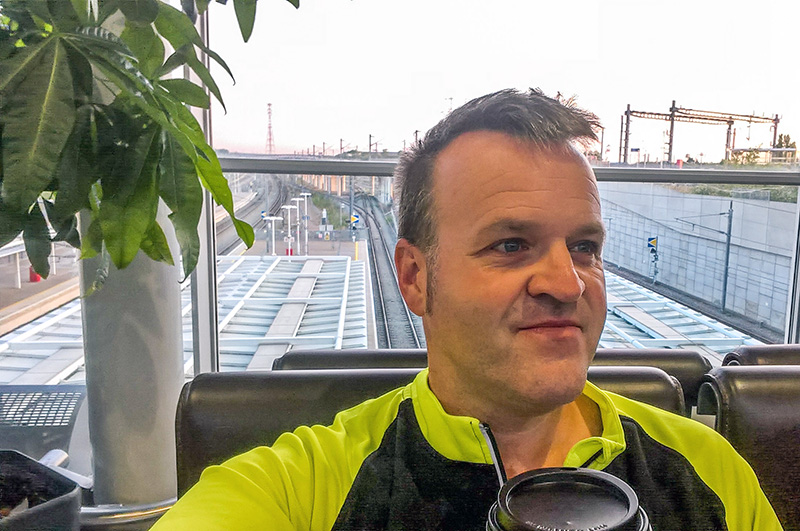
So it was that the Tuesday morning came much earlier than originally planned. My bike was already in London and would hopefully be there to meet me in Brussels. I was out of the house at an unearthly hour (it had a 4 at the start), had a top notch breakfast from the early morning McDonalds Drive Through in Ashford and was soon getting on the fast train to Ebbsfleet – looking a bit odd in all my cycling gear but without a bike. The amended plans, although adding a lot of time and a fair bit of money to the start of my trip (which I’m in the process of trying to claim back), had worked out well and I was soon checked in at Ebbsfleet and taking on more coffee to wake me up.


Next: Mons, Cambrai and The Somme
Mons, Cambrai and The Somme


The Somme (part two) and Agincourt


Ypres and Passchendaele


Dunkirk


Final Thoughts