Brighter to Bridlington
After the persistent rain of the previous day, it was a pleasant surprise to open the curtains of my 8th floor bedroom in the Radisson in York to be greeted by a bright and cheery day.
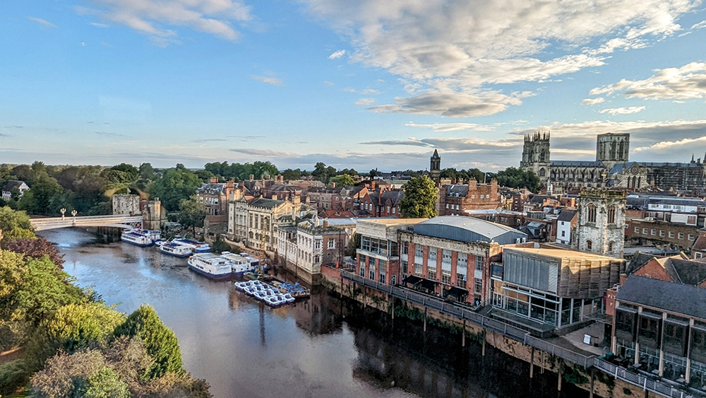
The same view as yesterday evening looked even more stunning with a blue sky. I started to get myself ready. My cycling gear from yesterday was still wet. Fortunately I had two sets with me; and though I was putting back on the clothes from Day One, they were dry (and only a little bit stinky – day one was a shorter day’s riding after all). The wet gear got double bagged (I’d picked up some bin bags the previous morning in Settle. Past experience of a wet day riding between the Somme and Agincourt had taught me the value of double bagging). With most of my kit ready, I headed downstairs for another excellent breakfast – admiring the even more stunning view across the Minster from the elevator lobby.
Breakfast was good; though apparently not as good as the one from the Golden Lion in Settle as I didn’t photograph it. Either that or I was so hungry I just wolfed it down.
After a quick retreat to the room to finally gather everything up I headed downstairs to check out and collect my bike from the secure staff parking area, then loaded it up and got ready to set off.
There are few better places to start a cycle ride than going through the heart of medieval York. I headed past the Minster and up through Goodramgate and out of Monkgate Bar. I was so happy to be cycling through the city gates that I was 100 yards through them when I realised my cycle computer was flashing to warn me that I was off route. I wasn’t actually supposed to have ridden through the bar so I had to double back and ride through it a second time!

Back on the correct route I left the City by crossing over the Fosse and found my way onto the former York to Beverley railway line.

A mix of railway path and quiet roads and farm tracks would take me through Dunnington and into Stamford Bridge.

More flat country lanes led me nice and steadily on towards Pocklington. I was taking it easy but the riding was easy and lovely. It was so much nicer to be out and about in clear blue skies.

Pocklington would mark the start of riding into the Yorkshire Wolds. It was also going to be biggest settlement I’d be in for a while so I decided to stop for a second breakfast. I pulled over at the first place I came across, Swirlz Gelato. I parked up, ordered a smoothie and a sweet crepe and settled down at an outside table. It was a good break and though barely two hours on since breakfast it was certainly a good choice.

A short way after leaving Pocklington on one its busier roads, a turning to the left and onto country lanes marked the start of the Yorkshire Wolds. The fields started to open up and the road rolled up and down (mostly up) into Millington and slowly and gradually onward and upwards. Around a corner the views opened up further to reveal a lovely valley ahead and the road dropped down to meet its floor.

From the valley bottom I now started to follow it back uphill. The climbing was largely gentle and never beyond mildly steep; although the valley on either side rose up steeply; reminding me of the chalk hills of Wilshire and Sussex I’ve spent so many years riding up.


I was briefly distracted by some fine looking highland cattle but got on my way and climbed up and out of the back of Millington Dale.

At the top, the landscape flattened back out into wide rolling views as I headed through Huggate and onwards towards Tibthorpe. Somewhere along this stretch a small but threatening looking cloud lived up to expectation as it opened up right above me with a sharp but short shower. I stopped to put my rain jacket on; and stopped again only another mile or two further on to take it back off again as the cloud passed over and the sun came back out.
I passed through Tibthorpe and into Kirkburn, and that was the Yorkshire Weald done and dusted. There was one last set of small hills before the coast, but the Weald had been the last proper set of hills of the whole trip and they had been steady going, but tackled without incident.
From Kirkburn its only about 4 miles into the centre of Driffield by the most direct route. However that route is along the busy A614 and so the Way of the Roses takes a detour along some country lanes in a loop to the south of the town, adding an additional 6 miles riding. These miles were pretty close to pan flat across some open arable land and pretty easy going, albeit with a fair breeze from the north west which the twisty turning route did head into for a fair part of the way.
At a junction before Hutton Cranswick the Way of the Roses joins with cycle route NCN1. NCN1 was a regular part of my riding in Kent when living in Sussex as it starts at the Port of Dover and heads around the Kent North and then northwards up the country. I’ve encountered it in a few other places, most notably in the North of Scotland and Orkney. I’d love to complete the full distance of the route all the way to the very top of Shetland; even if done in stages over many years. Adding a few miles of the route in Yorkshire was therefore something of a bonus.

At Hutton Cranswick, and again on entering Driffield, I’d also cross the Bridlington to Hull line on level crossings for the first two times. The last few miles from Skerne into Driffield were a bit tougher on account of being almost fully into the wind, but I kept pedalling and soon found myself turning into the Driffield main drag on a lively market day.

I found a bench at the top end of the high street, got a sandwich and some pop from a bakers and had a pleasant rest watching the world go by whilst sitting under some colourful, ornamental, umbrellas.

I enjoyed the rest but chivvied myself along into getting back onto the bike. I still had another 20 miles or thereabouts before I’d see the sea including one last final set of hills (even if they were the lowest on the route).
The route leaves Driffield heading east on a fairly busy road so I made the most of a shared footpath/cycleway alongside the route towards the pretty village of Nafferton at which point the route heads south again and over a third level crossing. Before too long a couple of left hand turns put me back northwards on an even quieter road bearing signs that the (fourth) level crossing ahead was closed to traffic. It is, but not to pedestrians or cyclists.
Once across the railway line again a couple of right hand turns around Harpham had me heading on another even more forlorn road to the fifth level crossing (cyclists and walkers only again) before almost immediately turning left onto a more open road and over the sixth (and final) level crossing; the last four of which had been crossed within 6 miles.
The final level crossing brought me into Burton Agnes and the start of the final set of hills. Some brown tourist signs at Burton Agnes suggested a couple of historic attractions in the form of a Hall and a Manor House. I stopped to look them up online and was pleased to see that the Manor House was a free to enter English Heritage property so I diverted into the car park to take a look. The advertising was a bit misleading. It is a ‘free’ EH property, but only if you pay to go into the hall in the grounds of which it sits. I didn’t have the time to properly get value for money on such a visit so I sadly headed back on my way and up into the final set of hills before the coast.
The climbing wasn’t difficult but I was quite tired now so it was also far from easy but I steadily made my way up the short climb to the ridge and onto the Roman Road heading towards Bridlington and Flamborough Head. The map shows a lot of potentially interesting historical and archaeological sites in this small area so I will have to come back another time and explore the area.
Heading East along the ridge I got my first look at the North Sea and the East Coast. The end was visible but I still had a few miles to go. Those are the hard miles when you know you’re almost there but not quite close enough. They passed slowly but pleasantly until the final descent to Bridlington.
Within Bridlington itself the route takes as long as possible to find a way to get you to the sea front. It is actually less than 2 miles from the Old Town around residential streets before suddenly arriving at the sea front. It felt longer.

Once on the prom, the sign marking the end of the ride appeared and I was happy to pull up and mark the ride from Morecambe as complete.

Well, almost complete. There was the small matter of riding back across town, this time along the prom and past all the seafront rock and tat stalls, arcades, and chip shops back to the rather pretty station. I had made it back a couple of hours before my booked train so I decided to pay for an earlier alternative and was soon settled onto the train, passing over the same six level crossings and through Hull to York, and then on to Darlington to the car and back home.

[osmap gpx=”https://www.richmay.co.uk/wp-content/uploads/2023/10/WotR3.gpx”]
Stats:
- Distance: 62.45 Miles
- Ride Time: 4 Hours 57 minutes and 17 seconds
- Average Speed: 12.6 mph
- Ascent: 1,706 feet
- Strava: https://www.strava.com/activities/9575252521